Topography
The Topography of the South India is worth to understand. This is a very important subject . Topography of a region Plays a very Important role.
Learn more about Topography of North-East and East India, North India and west India
Undoubtedly it provides great insight in the learning of Climate, Culture And temperature of the region. The food habits and the clothes also relate with the Topography.
The Guide to Indian Tourism definitely makes you understand the Topography of the Southern region of India.
Topography of the South India. An introduction.
In fact The terrain of southern India is nearly wholly made up of the Deccan plateau. The Two important mountain ranges in South India closely locate to the seashores. Undoubtedly these are the Western Ghats and Eastern Ghats mountain ranges.
The Aravalli and the Vindhyachal are the other well-known mountain ranges of India. The Vindhyanchal range separates the South India from North India.
South India Maps show varied topological and climatic patterns. Definitely It can be called a peninsula in the shape of a vast inverted triangle. A peculiar triangle bounded on the west by the Arabian Sea, on the east by Bay of Bengal and on north by the Vindhya and Satpura ranges.
Topography of the South India. And Western Ghats.
The Satpura ranges defines the northern spur of the Deccan plateau, one of the main geographic features of South India. The Western Ghats, along the western coast, marks another boundary of the plateau.
The narrow strip of verdant land between the Western Ghats and the Arabian Sea is the Konkan region. This is the southern area of the Narmada as falling in coastal Karnataka.
The Western Ghats continue south, forming the Malnad (Canara) region along the Karnataka coast. It terminates at the Nilgiri mountains, an inward (easterly) wing of the Western Ghats.
The Nilgiris run in a semi-circular shape approximately along the borders of Tamil Nadu . While northern Kerala and Karnataka, surrounding the Palakkad and Wayanad hills.
They further extending to the Satyamangalam ranges. Finally extending on to the relatively low-lying hills of the Eastern Ghats.
These western ghats are located on the western portion of the Tamil Nadu–Andhra Pradesh border. Undoubtedly The Tirupati and Anaimalai hills form part of this range.
Topography of the South India. And The Deccan Plateau.
The Deccan plateau, covering the major portion of the states of Maharashtra, Karnataka and Tamil Nadu. In fact this is the vast elevated region bound by the C-shape . Most importantly it is principally defined by all these mountain ranges. Finally It leans with gentle slope from the Western Ghats to the eastern coast.
To conclude
The Topography of the Southern India concludes diversity.
Please remember –Please follow our Blogs for Virtual Tour. We will met their and for sure take you to this entire new Journey.
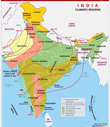
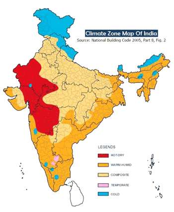
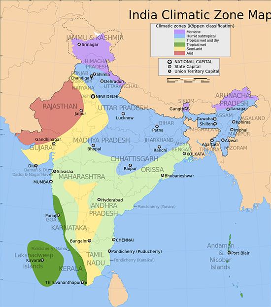


CLIMATE OF SOUTHERN INDIA
The region has a tropical climate and depends on monsoons for rainfall. … The region, which includes Karnataka, inland Tamil Nadu and western Andhra Pradesh, gets between 400 and 750 millimetres (15.7 and 29.5 in) of rainfall annually with hot summers and dry winters with temperatures.. READ MORE…………………………..
WE ARE HERE TO SERVE YOU. YOU MAY FIND OUR OTHER SERVICES ON OUR ‘SERVICE TAB’
POST YOUR COMMENTS. WE WANT TO HEAR FROM YOU. YOU MAY CONNECT US OR CONTACT US. DON’T FORGET TO BUILD RELATION. TRY ONCE WE WILL SURELY RESPOND. FOR SURE RELATION BUILDING IS A KEY TO SUCCESS.